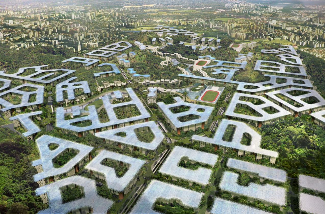
SIT Masterplan

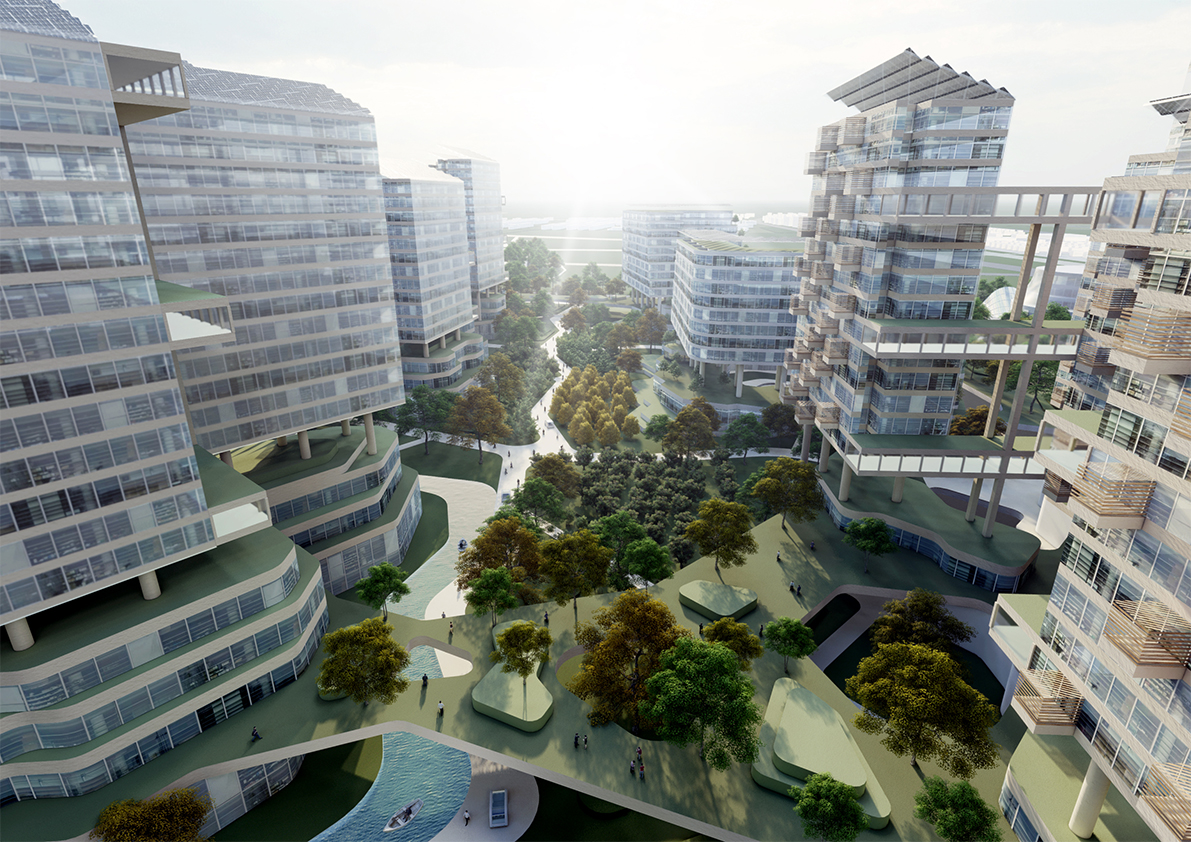
Located in Northeastern Singapore on a site containing an existing secondary rainforest, the new Singapore Institute of Technology Campus is envisaged as a fenceless campus with a publicly accessible ground plane containing community facilities and a new public park. The academic blocks are raised above this ground plane in a courtyard configuration to preserve a large portion of the existing trees at the centre of the campus and facilitate seamless connectivity between academic facilities.


This project adopts a 3D layered master planning approach, organized into four distinct strata. To create a fully walkable and car-lite precinct with a targeted public-to-private transportation mode share of 80:20, a superblock approach is adopted, supported by integrated major public transport facilities. A ‘vehicular and servicing layer’ contains car parking, servicing access, and district-level services within basements/partial grade.


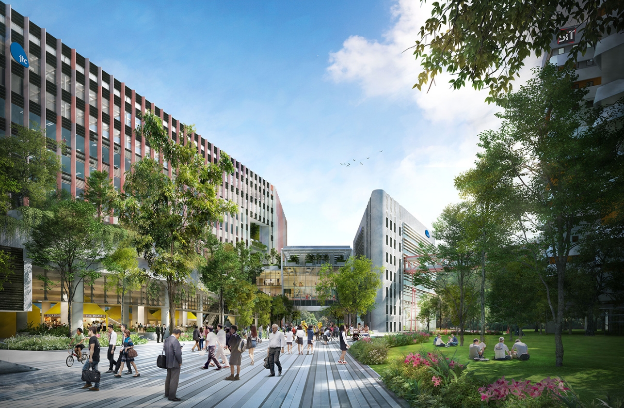
This is overlaid by a fully public, porous and pedestrianised ‘community park layer’ that encourages active mobility through seamless connectivity and activated public spaces from the town centre to the waterfront Market Village. Above ground, an interconnected ‘academic and office layer’ comprises shared classrooms, labs, and business park spaces. On the rooftop, a ‘tropical umbrella layer’ is made productive by incorporating large-scale PV arrays and urban farms that can offset 20% of the development’s energy consumption and feed 100% of the development’s population their daily ration of greens.


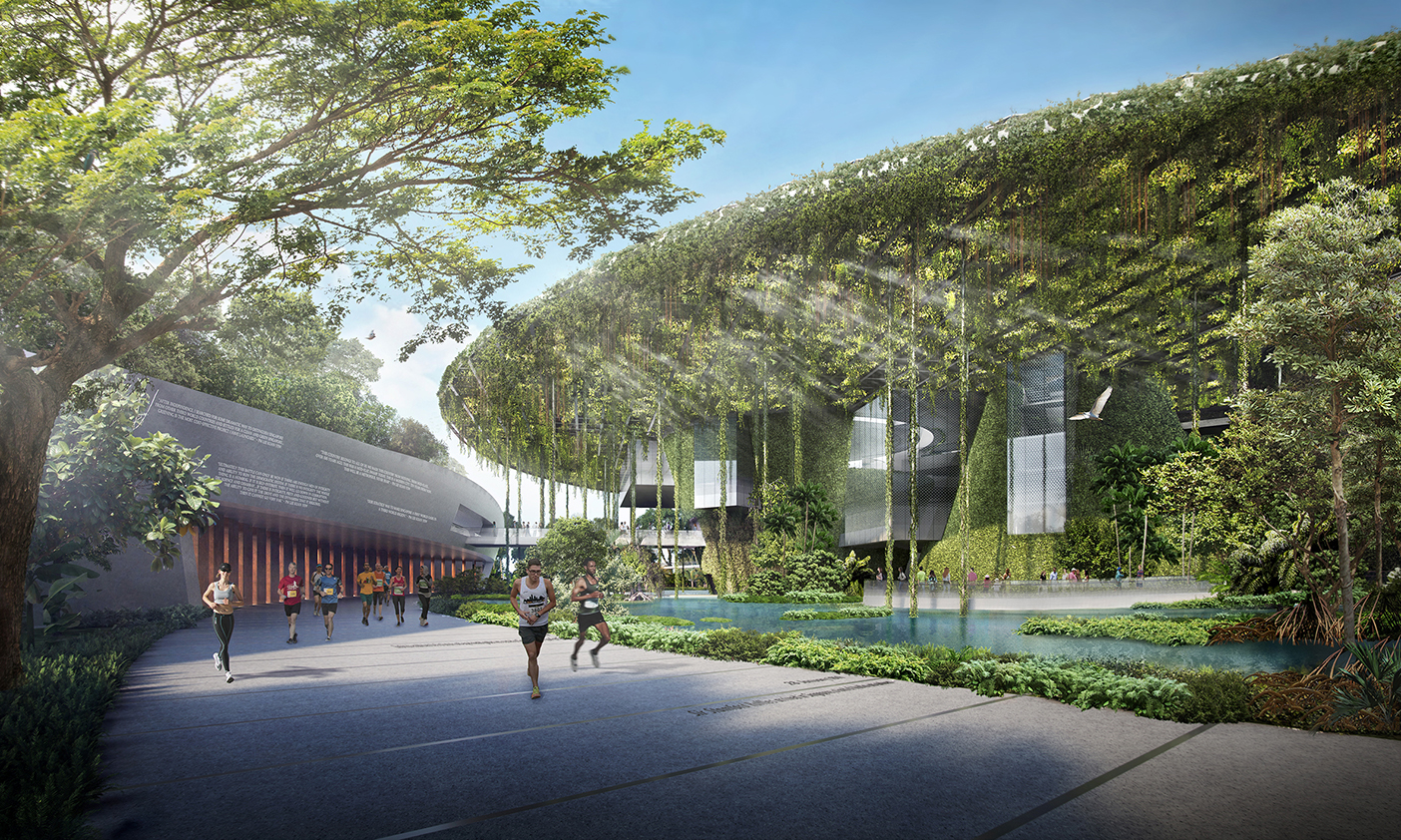
The entire campus is organised around a central 2Ha community park, which preserves an existing mature secondary rainforest. As a major public node at the intersection of two community spines, the park forms the heart of the campus, giving it an imageable identity and a strong sense of place. Strategic placement of the community park allows SIT to share this community space with both the adjacent business park and the surrounding residents while fostering industry-institution integration through a park-level ‘Campus Boulevard’ and an elevated ‘Collaboration Loop’.

Self-Sufficient City

Self-Sufficient City is a design concept for a new town in Indonesia that is regenerative, high density, high amenity, self-sufficient in food, energy and water, car-free and has high biodiversity and ecosystem services.

The brief was to house 210,000 people on a 730 Ha site that is overgrown with secondary rainforest and constrained by a 60m building height control limit. A 3-Dimensional master planning approach was adopted to create a tropical ‘eco-town-in-a-forest’, retaining over half of the existing green landscape.

Four distinct layers run through the town, integrating regenerative systems into the urban form:

  • A Transportation and Services Layer that segregates pedestrians from vehicles. Town-wide infrastructure includes pneumatic waste and recycling collection system, district cooling for the industrial estate and combined underground services tunnels under roads;
  • A Parkland Layer beneath blocks that comprises Tropical Community Spaces for public functions and social interaction. The Parkland Layer prioritizes people with well-connected mobility paths and trams, and a safe car-free environment within public gardens. A diverse topographic landscape, with terraced knolls and elevated decks, overlooks forest glades and the waterways of the town’s reservoir. Pavilions and venues for meetings, parties, and community events are located on the reservoir waterfront, along with boutique-style shops and cafés;
  • A Residential and Workplace Layer organized into a series of Breezeway Courtyards that form an Inverted Skyline;
  • A Rooftop Canopy Layer that is both protective and productive, providing shade and shelter as well as solar energy and food harvested from Sky Field crops. More than 3km2 of photovoltaic panels installed on the Rooftop Canopy Layer generate a 40MW system that can support the fully net zero energy town. With the Inverted Skyline typology, all building rooftops are capped at the same height, which ensures that no energy losses occur from over-shadowing.

NUS Sustainable and Resilient Building

More information coming soon.

Agri-food production in Singapore

More information coming soon.

Carnival of Life

The project showcases the Singapore story, reinforcing core values and cementing

Singapore as a beacon of transformative thinking. We imagine an ultra-Singapore that we know but can’t yet find – an experience that is super lush, tropical and shady, a blend of eating, shopping, and people-watching.

The Carnival of Life takes everything we love about Singapore and catapults it into the most desirable future to become a showcase to the world. It addresses how might we live better, longer and with lives filled with joy and wonder. The vision for the Carnival of Life creates a stage to answer these questions, while creating the most immersive and innovative attractions in Asia.

The Carnival of Life is tied together via a whimsical ribbon. This iconic promenade is a stage for community life and connects visitors to a sequence of attractions celebrating the best of Singapore, centred on food, water, and health. It is a new free lifestyle destination for Singaporeans, promoting community and wellbeing

Diverse yet thematically linked attractions are spread along The Ribbon, a linear park comprised of delightful public spaces.

We envision the Carnival of Life to be Singapore’s 4th Major Public Garden, creating a Regional Public Space for the North. Using Wonder, Multi-Sensory Exploration and Education, the Carnival of Life will be the most immersive and innovative masterplan of attractions in Asia, piloting and engaging global audiences in new regenerative ways of living.

Melides Masterplan

More information coming soon.

Future City Xicen

Xicen Country City masterplan presents a holistic solution for the upcoming development of a 7.1 km2 site on the southern bank of the Dianshan Lake, which is located in the Yangtze Delta area in close proximity to Shanghai, Hangzhou and Suzhou. The site has rich water network that takes up about one thirds of the total site area. This masterplan is a prototype for more livable and sustainable developments of the future that brings all the amenities and convenience typically found in existing metropoles in a location embraced by nature.

The proposed masterplan adopts a 50/50 City approach, allocating most of the urban development to the northern half of the site while preserving nature and indigenous culture in the southern half. In the urban half, surface vehicular roads are reduced to a minimum and the land is divided into a series of thematic islands in order to tap into the rich green and blue resources of the site, while celebrating the unique waterfront lifestyle of the Xicen region.

The Urban Core Islands have the highest density and programmatic mix with a district transport hub, civic/commercial plaza and arts/cultural center seamlessly connected to the metro and high-speed railway stations. The R&D Islands integrate garden offices, R&D facilities, and business incubators with residences to suit the future need of high-tech industries. The Residential Islands face the water and benefit from a natural biophilic environment. A series of Rewilding Islands are embedded into the urban spaces, allowing regenerative nature to render bioremediation and ecological services to the built environment.

The nature half is grouped into four zones: Eco-Tourism Zone, High-Tech High Intensity Farming Zone, Campus Village Zone and SME Creative Clusters Zone. By enhancing agricultural and energy production as well as inserting anchor industries and schools, Xicen Country City will become a selfsufficient and resilient urban typology wellequipped for all the future challenges and opportunities.

Future City Maqiao

Maqiao Future City is located in the southwest of Shanghai, 35 km away from the city center. It is the 20-hectare core development area of the future Shanghai AI Innovation Zone. The vision of this masterplan is to create an integrated new town as the driving engine for the larger region and a human-centric destination place that celebrates future live, learn, work and play. It will also be a demonstration project that aims to achieve carbon neutrality in phases.

The masterplan adopts the 50/50 City strategy, preserving half of the land for restorative and regenerative green and blue spaces and the other half for high-density high-amenity urban development, allowing a balanced synergy to grow between nature and the built environment. Programmatically it follows the same concept, proposing half of the development as residential spaces and the other half as a mix of R&D offices, commercial and community spaces.

Maqiao Future City consists of eight interconnected clusters, the Urban Core being the most dense and mixed-use. It integrates metro station, district transport hub, retail shops, urban plaza, and landmark buildings to create a welcoming gateway to the city and a vibrant civic center that forges a strong community spirit and sense of place.

Radiating out from the Urban Core are three Garden Office clusters with SOHO apartment blocks and various embedded business incubators that act as a physical and functional bridge between the urban spaces and the spaces left to nature. The waterfront residential clusters offer community spaces such as sports halls, schools, or healthcare centres.

A 3-dimensional planning strategy is introduced to bring things together. Vehicular roads, district infrastructures and services are buried underground, leaving the ground level fully pedestrianized and maximized for nature. Multiple landscaped ground levels are created above to facilitate stronger connection between clusters and further enhance the ecological system.

Founders' Memorial

The Founders’ Memorial presents a tribute to our founding fathers whose forging of a meritocratic and multi-racial society brought peace and prosperity; whose pursuit of national resilience drove a systemic approach towards sustainability; and whose vision of a “Clean and Green” Singapore uplifted the country’s image, spirit and economy. They have sown, and we, the people of Singapore, have reaped. To commemorate and celebrate the fruits of their labour, a memorial in the form of a Garden Monument is envisioned.

By gathering under the umbrella of this Forest of Giants, the Garden Monument instills a sense of reverence and awe, which in turn, inspires a renewed commitment to shade and shelter the future. Showcasing our City-in-a-Garden, a fully immersive visitor experience is created by weaving the story of Singapore through a layered tropical tapestry of water and greenery, light and shadow, breeze and shade.

The memorial derives its design language from this seamless melding of nature, architecture and infrastructure multi-dimensionally and multi-sensorially. Embodying Singapore’s Resilience Blueprint, the Garden + Monument concept is a synthesis of green, water and energy systems that look forward to our green and resilient future. It mirrors the systemic approach that our leaders took in the designing of modern Singapore, by innovatively bringing these infrastructures together to form a completely self-sustaining and self-sufficient constructed ecosystem.

Punggol Digital District Masterplan

Punggol North Masterplan is part of Singapore’s strategy to sustain long-term economic growth by creating new development areas island-wide, bringing jobs and social amenities closer to residents.

Punggol North is envisioned to be a vibrant and inclusive district underpinned by cutting-edge technology, as well as urban and social innovation which make everyday living more convenient and sustainable. As Singapore’s first Enterprise District, it will provide flexibility for the land use mix and scale to be curated at district-level, enabling deeper integration and synergy of different uses and spaces to realise the vision of the District. The District is also planned to be connected to the greater Punggol area, with a car-lite, green, and vibrant environment.

This is the first district in Singapore to adopt an integrated masterplan approach that brings together a business park, a university and community facilities and transport infrastructure. The district-level planning approach creates synergies, optimises land use and catalyses community building. It also allows us to design and integrate innovative technological platforms and from the ground up, transforming the way people work, live, learn and play in an inclusive and sustainable environment.

Phase 1 of the Masterplan has been completed in 2025 with the Punggol Digital District and Singapore Institute of Technology Campus.